 | Phang Nga Bay (Thai: อ่าวพังงา, RTGS: ao phangnga [ʔàːw pʰāŋ.ŋāː]) is a 400 km2 (150 sq mi) bay in the Andaman Sea between the island of Phuket and the... 5 KB (589 words) - 06:37, 26 January 2024 |
 | Phang Nga Bay to the south. Neighbouring provinces, from north and moving clockwise, are Ranong, Surat Thani, and Krabi. Towards the south of Phang Nga... 30 KB (2,311 words) - 16:15, 23 April 2024 |
 | Ao Phang Nga National Park (Thai: อุทยานแห่งชาติอ่าวพังงา), located in the Phang Nga Province of the Southern Thailand, encompasses parts of Mueang Phang... 9 KB (952 words) - 10:55, 8 December 2023 |
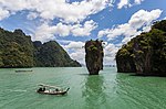
| Khao Phing Kan (category Geography of Phang Nga province) (เกาะเขาพิงกัน, [kɔ̀ʔ kʰǎw pʰīŋ kān]) is an island in Thailand, in Phang Nga Bay northeast of Phuket. About 40 metres (130 ft) from the shores of Khao... 14 KB (1,524 words) - 01:09, 10 April 2024 |
Nga Province Phang Nga district Phang Nga Bay Phang Nga River This disambiguation page lists articles associated with the title Phang Nga. If an internal... 248 bytes (67 words) - 15:15, 4 February 2024 |
 | groups in Thailand come in clusters of numerous individual islands: Phang Nga Bay has 67, the Mu Ko Chang National Park has 52, Tarutao National Marine... 51 KB (322 words) - 19:12, 4 May 2022 |
 | Ko Yao Yai (category Geography of Phang Nga province) big islands in the Ko Yao Archipelago. The island group is in Phang Nga Bay in the Phang Nga Province of southern Thailand. Ko Yao Yai means 'big long island'... 2 KB (182 words) - 12:02, 8 February 2024 |
 | the west coast of southern Thailand, where the Krabi River flows into Phang Nga Bay. The town lies 650 km (400 mi) south of Bangkok, and as of 2020, has... 16 KB (913 words) - 21:50, 22 March 2024 |
 | Takua Thung district (category Districts of Phang Nga province) was established on 26 October 1983. Most of the Phang Nga Bay coastline is part of the Ao Phang Nga National Park. The most important temple within the... 5 KB (307 words) - 15:48, 4 February 2024 |
 | (from north clockwise) Phang Nga, Surat Thani, Nakhon Si Thammarat, and Trang. Phuket province lies to the west across Phang Nga Bay. Krabi town is the seat... 34 KB (3,050 words) - 16:10, 23 April 2024 |