 | Paranaíba is the easternmost municipality in the Brazilian state of Mato Grosso do Sul. Its population was 42,276 (2020) and its area is 5,402.778 km2... 3 KB (40 words) - 00:24, 15 April 2024 |
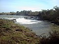
 | The Paranaíba River is a Brazilian river whose source lies in the state of Minas Gerais in the Mata da Corda mountains, municipality of Rio Paranaíba, at... 12 KB (1,337 words) - 19:01, 12 February 2024 |
 | Brazil Physical characteristics Source • location Goiás state Mouth Paranaíba River • coordinates 19°11′S 50°44′W / 19.183°S 50.733°W / -19.183;... 1 KB (37 words) - 05:58, 24 September 2023 |
 | Rio Paranaíba is a Brazilian municipality in the northwest of the state of Minas Gerais. Its population as of 2020 was 12,335 people living in a total... 4 KB (507 words) - 20:58, 1 May 2022 |
 | de Minas (N), Tiros and Arapuá (E), Ibiá and Rio Paranaíba (S), and Serra do Salitre (W). Rio Paranaíba: 28 km Patos de Minas: 54 km Belo Horizonte: 362 km... 5 KB (530 words) - 23:25, 12 April 2024 |
 | Alto Paranaíba is one of the ten planning regions of the state of Minas Gerais in Brazil. Paranaiba is bordered: to the north and northeast by the north... 1 KB (95 words) - 12:23, 20 August 2023 |
 | named after the Paranaíba River. The name paranabia comes from the Tupi language. It means "large river with muddy water". "Boana paranaiba (Carvalho and... 3 KB (301 words) - 15:45, 5 April 2024 |
is a river of Goiás state in central Brazil. It is a tributary of the Paranaíba River. List of rivers of Goiás "Mapa Rodoviário Goiás" (map). zonu.com... 1 KB (48 words) - 13:40, 17 February 2023 |
is a river of Goiás state in central Brazil. It is a tributary of the Paranaíba River, which it enters in the reservoir created by Ilha Solteira Dam,... 1 KB (89 words) - 13:28, 17 February 2023 |
 | Noteworthy is the Rio Grande, which born in Minas Gerais and join with Paranaiba to form the Parana River, which separates São Paulo from Mato Grosso do... 152 KB (16,119 words) - 14:30, 2 May 2024 |