
The Pahvant Range (also Pavant Range) is a mountain range in central Utah, United States, east of Fillmore. The range is named for the Pahvant tribe, a...
4 KB (232 words) - 23:17, 24 April 2022

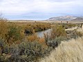
The Pahvant or Pahvants (Pavant, Parant, Pahva-nits) were a band of Ute people that lived in present-day Utah. Called the "Water People", they fished...
9 KB (1,105 words) - 06:22, 19 June 2023
specifically, the East Tintic, Gilson, and Canyon Mountains; also the massive Pahvant Range. The Sevier Desert contains the course of the Sevier River in a circuitous...
11 KB (731 words) - 21:28, 19 March 2021
west side of the Round Valley in eastern Millard County at base of the Pahvant Range Maple Grove, Virginia Maple Grove, Washington Maple Grove, Wisconsin...
1 KB (186 words) - 16:41, 15 March 2022

Pahvant Butte (also Pavant Butte) is a tuff cone volcano in the west-central portion of Utah, United States. The butte, sometimes called "Sugarloaf Mountain"...
8 KB (814 words) - 01:57, 22 March 2024

feet (1,565 m) in elevation. It lies in the Pahvant Valley, near the base of the Pahvant Mountain Range. According to the United States Census Bureau...
14 KB (1,100 words) - 20:09, 22 April 2024

over the Pahvant Range, cresting at Clear Creek Summit with an elevation of 7,180 feet (2,190 m). The eastern descent from the Pavant range features bridges...
45 KB (4,791 words) - 13:14, 19 April 2024
located in the Pahvant Valley. Its source is at the confluence of East Fork Corn Creek and West Fork Corn Creek in the Pahvant Range. The location near...
5 KB (593 words) - 17:02, 2 October 2023
112°07′12″W / 39.11306°N 112.12000°W / 39.11306; -112.12000 in the Pahvant Range. U.S. Geological Survey Geographic Names Information System: Wild Goose...
545 bytes (95 words) - 12:08, 28 May 2022
112°07′13″W / 39.11250°N 112.12028°W / 39.11250; -112.12028 in the Pahvant Range. List of rivers of Utah LeRoy Reuben Hafen, Ann Woodbury Hafen, Journals...
2 KB (251 words) - 13:29, 16 March 2023