 | similar to Google Maps and Bing Maps. It is open-source, provided under the 2-clause BSD License. OpenLayers supports GeoRSS, KML (Keyhole Markup Language)... 3 KB (207 words) - 09:50, 23 April 2024 |
and display them using layer.bindTooltip, layer.bindPopup etc. Leaflet is directly comparable with OpenLayers, as both are open source, client-side only... 14 KB (1,405 words) - 11:18, 23 April 2024 |
 | "Google Projection: 900913". August 7, 2007. "Spherical Mercator — OpenLayers". docs.openlayers.org. Archived from the original on 2021-04-18. Retrieved 2018-11-12... 15 KB (1,702 words) - 11:03, 26 January 2024 |
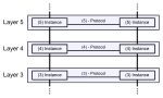 | OSI model (redirect from OSI seven-layer model) application. Each intermediate layer serves a class of functionality to the layer above it and is served by the layer below it. Classes of functionality... 51 KB (5,416 words) - 19:24, 19 April 2024 |
 | Layering is a vegetative propagation technique where the stem or branch of a plant is manipulated to promote root development while still attached to the... 8 KB (1,108 words) - 19:41, 8 January 2024 |
 | by OpenLayers. One difference is the y axis is positive northwards in TMS, and southwards in OpenStreetMap. Web Map Tile Service: a more recent Open Geospatial... 5 KB (680 words) - 00:56, 31 December 2023 |
systems software Comparison of geographic information systems software OpenLayers Semantic Sensor Web Weather Information Exchange Model GTFS "OGC – current... 13 KB (994 words) - 19:01, 12 April 2024 |
web-based maps such as OpenLayers, Leaflet, Google Maps and Bing Maps. GeoServer functions as the reference implementation of the Open Geospatial Consortium... 6 KB (560 words) - 10:29, 13 April 2023 |
interface based on the Leaflet JavaScript library (and formerly built on OpenLayers), displaying map tiles rendered by the Mapnik rendering engine The basic... 67 KB (5,938 words) - 10:44, 17 April 2024 |
Web Map Service (category Open Geospatial Consortium) Tableau Open source software that supports WMS include: QGIS uDig OpenJUMP MapGuide Open Source NASA World Wind GRASS GIS GeoTrellis JOSM gvSIG OpenLayers Leaflet... 8 KB (851 words) - 15:01, 23 April 2024 |