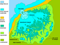
 | The North Slob is an area of mud-flats at the estuary of the River Slaney at Wexford Harbour, Ireland. The North Slob is an area of 10 km2 (2,500 acres)... 6 KB (419 words) - 02:22, 29 March 2024 |
 | Meelin, County Cork, Republic of Ireland (254 m / 832 ft) Lowest point: North Slob, County Wexford, Republic of Ireland Many points are on, or near sea level... 7 KB (929 words) - 11:09, 7 April 2024 |
 | 44 m (−11.3 ft) 13= parts of West Flanders Belgium −3 m (−10 ft) 13= North Slob, County Wexford Ireland −3 m (−10 ft) 15 The Fens United Kingdom −2.75 m... 16 KB (471 words) - 04:37, 8 March 2024 |
 | Staffordshire, England at 463 m (1,519 ft) above sea level. Lowest Point — North Slob, County Wexford, Ireland at 3 m (10 ft) below sea level. Extreme points... 2 KB (157 words) - 13:28, 10 April 2019 |
managing director of the Guinness Breweries, went on a shooting party in the North Slob, by the River Slaney in County Wexford, Ireland. After missing a shot... 53 KB (4,601 words) - 20:46, 2 May 2024 |
 | a float in Wexford, is used traditionally to shoot game birds in the North Slob mud flats. The Saltee Islands lie 5 km (3 mi) offshore from Kilmore Quay... 60 KB (5,528 words) - 13:18, 19 April 2024 |
 | Mudflats or mud flats, also known as tidal flats or, in Ireland, slob or slobs, are coastal wetlands that form in intertidal areas where sediments have... 13 KB (1,356 words) - 18:20, 15 March 2024 |
 | with large mud flats on both sides. These were known as the North Slob and the South Slob from the Irish word slab, meaning mud. It contained several... 11 KB (1,490 words) - 15:33, 27 September 2023 |
 | British Isles (redirect from North East Atlantic Archipelago) Britain particularly low-lying: the lowest point in the islands is the North Slob in County Wexford, Ireland, with an elevation of −3.0 metres (−9.8 ft)... 88 KB (9,482 words) - 20:29, 2 April 2024 |
 | Earth. The summit of Denali is the highest point of the United States and North America. The summit of Mount Logan is the highest point of Canada. The summit... 49 KB (2,037 words) - 21:51, 20 April 2024 |