
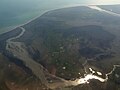
plateaus to the north. Kirkjubæjarklaustur is roughly 190 kilometres (120 mi) east of the capital Reykjavik. Kirkjubæjarklaustur's geographical location...
12 KB (747 words) - 10:29, 11 April 2024

Systrafoss, in Kirkjubæjarklaustur Þjófafoss on the Merkurhraun lava fields Öxarárfoss, at Þingvellir National Park Fagrifoss, near Kirkjubæjarklaustur Morsárfoss...
9 KB (334 words) - 11:52, 25 December 2023

The tallest tree in Iceland is a sitka spruce planted in 1949 in Kirkjubæjarklaustur; it was measured at 25.2 m (83 ft) in 2013. Algae such as Chondrus...
227 KB (20,608 words) - 20:02, 18 May 2024

far from the volcanic fissure of Eldgjá and the small village of Kirkjubæjarklaustur. The fissure is properly referred to as Lakagígar, while Laki is...
30 KB (3,395 words) - 20:27, 26 April 2024
long. It is located near the Ring Road, not far from the village of Kirkjubæjarklaustur. Its origins dates back to the cold periods of the Ice Age, about...
4 KB (294 words) - 22:10, 14 April 2024
road construction; the third, easternmost branch, which flows near Kirkjubæjarklaustur, retains the name Skaftá but has extremely low water levels when...
7 KB (542 words) - 04:29, 28 October 2023

Eskifjörður Fáskrúðsfjörður Stöðvarfjörður Breiðdalsvík Djúpivogur Höfn Kirkjubæjarklaustur Vík í Mýrdal (Vík) Skógar Hvolsvöllur Hella Selfoss Hveragerði During...
19 KB (2,029 words) - 17:16, 16 April 2024
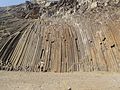
Dverghamrar, Kirkjubæjarklaustur Gerðuberg Hellnahraun near Arnarstapi, Snæfellsbær Hljóðaklettar, Jökulsárgljúfur Kirkjugólf, Kirkjubæjarklaustur Kálfshamarsvík...
28 KB (2,330 words) - 21:24, 12 May 2024

Skaftárhreppur (Icelandic pronunciation: [ˈskaftˌaur̥ˌr̥ɛhpʏr̥] ) is a municipality in southern Iceland. The largest settlement is Kirkjubæjarklaustur. v t e...
2 KB (18 words) - 08:48, 28 October 2023

Breiðamerkursandur and the river Skeiðará, east of the village of Kirkjubæjarklaustur and South, West and East of the Öræfajökull volcano. It has been...
2 KB (185 words) - 11:07, 16 February 2024