
Tavira Island (redirect from Ilha de tavira)
Tavira Island (Portuguese: Ilha de Tavira) lies south of the town of Tavira, Portugal, just a few hundred metres off the coast. It is 11 kilometres long...
4 KB (282 words) - 13:48, 2 August 2022
Valdemar (2 February 1995), "Quatrocentos Anos de Santa Luzia de Angra", Boletim da Instituto Histórico da Ilha Terceira (PDF) (in Portuguese), Angra do Heroísmo...
4 KB (455 words) - 00:23, 15 April 2024

Pico Island (redirect from Ilha do Pico)
Pico Island (Ilha do Pico, Portuguese pronunciation: [ˈiʎɐ ðu ˈpiku]) is an island in the Central Group of the Portuguese Azores. The landscape features...
44 KB (4,408 words) - 12:30, 17 August 2024

can be reached via the nearby Santa Luzia footbridge or by ferry, taking visitors to the sand-bar island known as Ilha de Tavira, part of the Ria Formosa...
19 KB (1,550 words) - 15:01, 2 September 2024

Terceira Island (redirect from Ilha Terceira)
Ribeirinha Santa Bárbara Santa Cruz Santa Luzia São Bartolomeu de Regatos São Bento São Brás São Mateus da Calheta São Pedro Sé Serreta Terra Chã Vila de São...
38 KB (4,675 words) - 01:19, 9 August 2024

earthquake (13 May 1958) 1964 Rosais earthquake (21 February 1964) 1973 Santa Luzia-Santo António earthquake (23 November 1973) 1980 Azores Islands earthquake...
3 KB (316 words) - 23:23, 8 January 2024

Barlavento Islands (redirect from Ilhas de Barlavento)
two sub-groups: in the west: Santo Antão, São Vicente, São Nicolau, Santa Luzia and islets Branco and Raso are volcanic and somewhat rocky yet quite...
2 KB (248 words) - 13:00, 24 February 2021
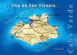
São Vicente, Cape Verde (category CS1 German-language sources (de))
coast. It is located between the islands of Santo Antão and Santa Luzia, with the Canal de São Vicente separating it from Santo Antão. The island is roughly...
24 KB (2,155 words) - 21:08, 13 June 2024
11°21′03″S 37°26′52″W / 11.35083°S 37.44778°W / -11.35083; -37.44778 Santa Luzia do Itanhy is a municipality located in the Brazilian state of Sergipe...
648 bytes (54 words) - 21:18, 12 April 2024
affected Santa Luzia in Pico between 12 and 15 December. It made seismographs from Faial registered a volcanic tremor at Cachorro, Santa Luzia on the north...
27 KB (3,938 words) - 10:43, 1 April 2024