 | The Geospatial Information Authority of Japan (国土地理院, Kokudo Chiri-in), or GSI, is the national institution responsible for surveying and mapping the... 6 KB (598 words) - 21:22, 10 January 2024 |
 | on paper maps. On February 28, 2023, the Geospatial Information Authority of Japan announced that the number of islands had been updated to 14,125 through... 21 KB (1,229 words) - 03:22, 14 April 2024 |
Mountains of Japan. Mt. Nakanodake:Hiking route|Snow Country "List of Japanese mountains" (in Japanese). Geospatial Information Authority of Japan. Retrieved... 28 KB (126 words) - 16:58, 31 March 2024 |
 | by prefectures and municipalities (as of October 1)] (in Japanese). Geospatial Information Authority of Japan. December 26, 2019. Archived from the original... 173 KB (15,154 words) - 01:21, 17 April 2024 |
 | 2024 Noto earthquake (redirect from 2024 Sea of Japan earthquake) distribution data] (in Japanese). Geospatial Information Authority of Japan. 7 January 2024. Retrieved 18 January 2024. "Japan quake death toll tops 100"... 238 KB (22,917 words) - 16:10, 17 April 2024 |
 | Tokyo (redirect from Tokyo, Japan) "Mountains of Tokyo Metropolis" (in Japanese). Geospatial Information Authority of Japan. Retrieved April 28, 2020. "東京都の人口(推計)とは" [Population of Tokyo(estimate)]... 147 KB (11,614 words) - 11:27, 18 April 2024 |
 | Amami Islands (redirect from History of the Amami Islands) part of the Ryukyu Islands, and is southwest of Kyushu. Administratively, the group belongs to Kagoshima Prefecture, Japan. The Geospatial Information Authority... 23 KB (2,388 words) - 21:46, 26 September 2023 |
 | Subsidence (category CS1 uses Japanese-language script (ja)) settling and compacting of unconsolidated sediment from the shaking of an earthquake. The Geospatial Information Authority of Japan reported immediate subsidence... 16 KB (2,132 words) - 08:15, 22 January 2024 |
 | Ministry of Internal Affairs and Communications of Japan Intercensal Adjustment of Current Population Estimates 2010 – 2015 "地形分類" (PDF). Geospatial Information... 138 KB (7,815 words) - 13:31, 16 April 2024 |
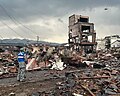
 | 2011 Tōhoku earthquake and tsunami (redirect from Great Japan Earthquake of 2011) caused by 2011 Tōhoku earthquake and tsunami] (in Japanese). Geospatial Information Authority of Japan. 14 April 2011. Archived from the original on 20... 237 KB (22,317 words) - 17:39, 12 April 2024 |