 | The Geography of West Bengal, a state in eastern India, is primarily defined by plains and plateaus, with the high peaks of the Himalayas in the north... 30 KB (3,538 words) - 07:25, 1 April 2024 |
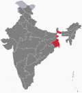 | Geography of West Bengal West Bengal is: an Indian state Population of West Bengal: Area of West Bengal: 88,750 km2 Atlas of West Bengal West Bengal is... 10 KB (639 words) - 05:17, 1 April 2024 |
 | The climate of West Bengal is varied, with tropical savannahs in the southern portions of the state, to humid subtropical areas in the north. Temperatures... 44 KB (2,232 words) - 17:05, 22 April 2024 |
highest peak in the southern West Bengal on Ajodhya Hills of the extended Eastern Ghats. Joychandi Pahar Geography of West Bengal List of mountains in India... 3 KB (97 words) - 18:47, 7 April 2024 |
 | West Bengal (/bɛnˈɡɔːl/, Bengali: Poshchim Bongo, pronounced [ˈpoʃtʃim ˈbɔŋɡo] , abbr. WB) is a state in the eastern portion of India. It is situated... 205 KB (17,192 words) - 14:37, 26 April 2024 |
South Bengal (Bengali: দক্ষিণবঙ্গ/দক্ষিণ বাংলা) is a term used for the southern parts of Bengal including Southern Bangladesh and Southern West Bengal, state... 8 KB (353 words) - 17:16, 18 April 2024 |
 | North Bengal (Bengali: উত্তরবঙ্গ/উত্তর বাংলা) is a term used for the north-western part of Bangladesh and northern part of West Bengal. The Bangladesh... 15 KB (1,471 words) - 16:39, 30 October 2023 |
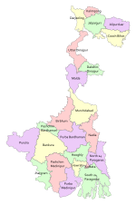 | state. Geographically, West Bengal is divided into a variety of regions—Darjeeling Himalayan hill region, Terai and Dooars region, North Bengal plains... 43 KB (2,661 words) - 10:21, 22 April 2024 |
 | culture of West Bengal is an Indian culture which has its roots in Bengali literature, music, fine arts, drama and cinema. Different geographic regions of West... 19 KB (1,881 words) - 04:59, 21 January 2024 |
 | the west, the Lakshadweep Sea to the southwest, the Bay of Bengal on the east, and the Indian Ocean proper to the south. The Palk Strait and Gulf of Mannar... 74 KB (8,494 words) - 22:32, 22 April 2024 |