
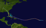
Description2017 Atlantic hurricane season summary map.png English: This map shows the tracks of all tropical cyclones in the 2017 Atlantic hurricane season. The...
(4,000 × 2,476 (6.24 MB)) - 12:19, 12 November 2023

Description2017 Atlantic hurricane season summary.png English: This map shows the tracks of all tropical cyclones in the 2017 Atlantic hurricane season. The points...
(4,000 × 2,476 (6.32 MB)) - 12:19, 12 November 2023
Commons Attribution-Share Alike 4.0 truetrue English Track map of Hurricane Irma in 2017 author name string: Wxtrackercody Wikimedia username: Wxtrackercody...
(2,700 × 1,668 (2.28 MB)) - 06:49, 12 April 2024

Description1899 Atlantic hurricane 8 track.png English: Track map of Tropical Storm Eight of the 1899 Atlantic hurricane season. The points show the location...
(1,024 × 633 (377 KB)) - 22:22, 2 April 2023

https://www.nesdis.noaa.gov/news/la-nina URL: https://nesdis-prod.s3.amazonaws.com/migrated/LaNina.png determination method: JImagehash perceptual hash...
(4,096 × 2,048 (7.26 MB)) - 11:58, 14 August 2024

English Arabic مسار الإعصار لي في موسم أعاصير المحيط الأطلسي ٢٠١٧...
(3,000 × 3,000 (634 KB)) - 18:22, 27 February 2023
DescriptionArlene 2017 track.png English: Track map of Tropical Storm Arlene of the 2017 Atlantic hurricane season. The points show the location of the...
(3,000 × 1,854 (436 KB)) - 11:38, 14 September 2023

Description1946 Atlantic tropical storm 5 track.png English: Track map of Tropical Storm Five of the 1946 Atlantic hurricane season. The points show the...
(2,700 × 1,669 (277 KB)) - 15:03, 5 April 2023

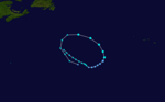
Description10L 2017 track.png English: Track map of Potential Tropical Cyclone Ten of the 2017 Atlantic hurricane season. The points show the location...
(2,700 × 1,669 (3.24 MB)) - 08:49, 14 March 2023

DescriptionJose 2017 path.png English: Track map of Hurricane Jose of the 2017 Atlantic hurricane season. The points show the location of the storm at...
(3,000 × 2,499 (1.54 MB)) - 17:21, 13 February 2024