 | Earth Gravitational Model (redirect from EGM96) resolution. Three model versions have been published: EGM84 with n=m=180, EGM96 with n=m=360, and EGM2008 with n=m=2160. n and m are the degree and orders... 11 KB (1,292 words) - 21:52, 26 April 2024 |
 | different mean sea levels as reference, but most commonly refers to the EGM96 geoid. In maps and common use, the height over the mean sea level (such... 26 KB (3,056 words) - 23:24, 18 April 2024 |
elevations are described as the height above the Earth Gravitational Model 1996 (EGM96) geoid, not the WGS84 reference ellipsoid. DTED supports many applications... 3 KB (280 words) - 08:43, 22 April 2024 |
Altitude, the vertical component, is measured in meters from the WGS84 EGM96 Geoid vertical datum. If altitude is omitted from a coordinate string, e... 8 KB (779 words) - 04:59, 7 March 2024 |
 | Botrange (694 m TAW) as Belgium's highest point because its vertical reference EGM96 deviates a couple of meters from the German Normalnull and the Belgian TAW... 3 KB (242 words) - 17:24, 16 April 2024 |
| Details". EPSG Geodetic Parameter Dataset. Retrieved 21 December 2022. "The EGM96 Geoid Undulation with Respect to the WGS84 Ellipsoid". NASA. European Organisation... 24 KB (2,809 words) - 05:56, 18 March 2024 |
 | elevations were calculated relative to the WGS84 ellipsoid and then the EGM96 geoid separation values were added to convert to heights relative to the... 21 KB (2,107 words) - 07:14, 26 December 2023 |
 | alternative is to use a geoid-based vertical datum such as NAVD88 and the global EGM96 (part of WGS84). Details vary in different countries. When referring to... 23 KB (4,395 words) - 03:20, 18 April 2024 |
| determined by geodetic-geophysical models of the subsurface. Clairaut's theorem EGM96 Gravity formula Gravity of Earth Horizon §§ Distance and Curvature Meridian... 23 KB (2,821 words) - 15:15, 24 April 2024 |
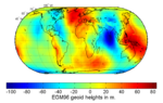
 | Map of the undulation of the geoid in meters (based on the EGM96)... 8 KB (1,681 words) - 17:55, 20 March 2024 |