 | Petén (from the itz'a, Noj Petén, 'Great Island') is a department of Guatemala. It is geographically the northernmost department of Guatemala, as well... 19 KB (1,430 words) - 15:08, 26 April 2024 |
department of El Petén in Guatemala. The municipality is formed by the town of San Andrés, located on the north-western shore of Lake Petén Itzá, and 55 rural... 6 KB (134 words) - 08:30, 14 April 2024 |
Poptún (category Municipalities of the Petén Department) (PDF) on 26 November 2011. Retrieved 29 June 2015. "Municipios del Departamento de El Petén". SEGEPLAN (in Spanish). Guatemala. Archived from the original... 3 KB (176 words) - 04:01, 17 January 2023 |
8. Collectif 2011, p. 9. SEGEPLAN. "Municipios del departamento de El Petén". Secretaría General de Planificación (in Spanish). Guatemala. Archived from... 9 KB (725 words) - 14:41, 21 April 2024 |
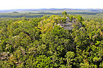
 | Maya civilization (section Central Petén) The Petén region consists of densely forested low-lying limestone plain; a chain of fourteen lakes runs across the central drainage basin of Petén. To... 183 KB (22,561 words) - 03:04, 1 March 2024 |
 | fourteen lakes runs across the central drainage basin of Petén. The largest lake is Lake Petén Itza; it measures 32 by 5 kilometres (19.9 by 3.1 mi). A... 169 KB (21,539 words) - 02:11, 23 April 2024 |
 | Sayaxché (category Municipalities of the Petén Department) Municipio de Sayaxché, departamento de Petén (PDF) (in Spanish). Guatemala: Facultad de Ciencias Económicas de la Universidad de San Carlos de Guatemala... 12 KB (755 words) - 18:45, 4 February 2024 |
 | mountainous, except for the south coastal area and the vast northern lowlands of Petén department. The country is located in Central America and bounded to the... 16 KB (1,224 words) - 17:15, 8 February 2024 |
 | Regional del Sureste de Petén ("Southeastern Petén Regional Museum") is an archaeological museum in the town of Dolores in the Petén Department of Guatemala... 14 KB (1,270 words) - 08:59, 28 January 2024 |
 | El Mirador (category Maya sites in Petén Department) AD) Maya settlement, located in the north of the modern department of El Petén, Guatemala. It is part of the Mirador-Calakmul Karst Basin of northern Guatemala... 26 KB (3,094 words) - 15:28, 29 February 2024 |