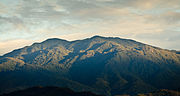
Cerro de la Muerte is a mountain peak of a massif in Costa Rica, it is located within the Tapantí — Cerro de la Muerte Massif National Park, and is the...
4 KB (547 words) - 13:18, 8 May 2024

The Cerro de la Muerte Biological Station is one of the several field stations for biological research that exist in Costa Rica. Located at 3,200 m elevation...
3 KB (373 words) - 20:12, 18 August 2022

Tapantí - Cerro de la Muerte Massif National Park, (Spanish: Parque Nacional Tapantí - Macizo Cerro de la Muerte), is a national park in the Central Conservation...
5 KB (397 words) - 18:56, 1 January 2024

Rica and Panama, among them Cerro Chirripó at 3,820 metres (12,530 ft), and the more accessible high peak of Cerro de la Muerte. Much of the Caribbean areas...
7 KB (749 words) - 15:27, 29 July 2023

Protected Zone Sombrero River–Navarro River Protected Zone Tapantí-Cerro de la Muerte Massif National Park Tapiria Wildlife Refuge Tiribí River Protected...
3 KB (223 words) - 19:20, 27 October 2023

The highest point in the entire Pan-American Highway occurs at the Cerro de la Muerte (Death Hill) in the Carretera Interamericana Sur segment, at 3,335 m...
70 KB (8,694 words) - 02:54, 15 May 2024

Central Conservation Area and the Cartago Province, Cerro de la Muerte, Villa Mills, in Cordillera de Talamanca. The length of the forewings is 2.2-3.7 mm...
2 KB (90 words) - 21:50, 4 May 2024
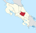
connected to San José via a four-lane highway. The highest peak is Cerro de la Muerte at 3,600 meters above sea level, and the lowest point of the province...
5 KB (268 words) - 08:24, 12 April 2024

near Cerro de la Muerte in November 2020 due to the indirect effects of Hurricane Eta. Leandro, Harold (16 April 2017). "¿Cruzar el Cerro de la Muerte sin...
12 KB (981 words) - 20:37, 25 January 2023

Gracillariidae. It is known only from Cerro de la Muerte, Villa Mills, at 3,100 m elevation in the Cordillera de Talamanca in Costa Rica. The length of...
2 KB (90 words) - 21:50, 4 May 2024