 | In geometry, a Cartesian coordinate system (UK: /kɑːrˈtiːzjən/, US: /kɑːrˈtiːʒən/) in a plane is a coordinate system that specifies each point uniquely... 40 KB (5,501 words) - 11:14, 16 April 2024 |
 | unique coordinate and each real number is the coordinate of a unique point. The prototypical example of a coordinate system is the Cartesian coordinate system... 19 KB (2,265 words) - 23:43, 7 January 2024 |
 | reference systems that are in use, and forms the basis for most others. Although latitude and longitude form a coordinate tuple like a cartesian coordinate system... 21 KB (2,380 words) - 18:12, 4 April 2024 |
| national systems such as the British National Grid, and State Plane Coordinate System (SPCS). Engineering coordinate system (or local, custom) A cartesian coordinate... 15 KB (1,546 words) - 22:10, 9 April 2024 |
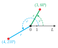 | direction. The reference point (analogous to the origin of a Cartesian coordinate system) is called the pole, and the ray from the pole in the reference... 47 KB (6,600 words) - 02:28, 5 April 2024 |
 | A Cartesian coordinate robot (also called linear robot) is an industrial robot whose three principal axes of control are linear (i.e. they move in a straight... 9 KB (996 words) - 11:00, 22 July 2023 |
 | +a} , respectively, on the x {\displaystyle x} -axis of the Cartesian coordinate system. The most common definition of elliptic coordinates ( μ , ν )... 9 KB (1,599 words) - 16:25, 17 November 2023 |
| In mathematics, a spherical coordinate system is a coordinate system for three-dimensional space where the position of a given point in space is specified... 42 KB (6,283 words) - 18:04, 20 April 2024 |
 | A projected coordinate system – also called a projected coordinate reference system, planar coordinate system, or grid reference system – is a type of... 21 KB (2,802 words) - 02:18, 12 April 2024 |
simple Cartesian coordinate system to specify locations rather than a more complex spherical coordinate system (the geographic coordinate system of latitude... 7 KB (965 words) - 15:06, 26 February 2024 |