 | Bikini Bikini Atoll (/ˈbɪkɪˌniː/ or /bɪˈkiːni/; Marshallese: Pikinni, [pʲiɡinnʲi], lit. 'coconut place'), known as Eschscholtz Atoll between the 19th century... 93 KB (10,372 words) - 19:32, 16 April 2024 |
 | Map all coordinates in "Nuclear testing at Bikini Atoll" using OpenStreetMap Download coordinates as: KML GPX (all coordinates) GPX (primary coordinates)... 62 KB (6,059 words) - 09:26, 27 March 2024 |
 | after the Bikini Atoll, where the first public test of a nuclear bomb had taken place four days before. Due to its revealing design, the bikini was once... 134 KB (12,910 words) - 04:25, 24 April 2024 |
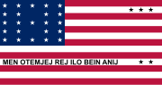 | The flag of Bikini Atoll, a member of the Marshall Islands, closely resembles the flag of the United States and was adopted in 1987. The flag is symbolic... 3 KB (353 words) - 17:35, 10 April 2024 |
 | Atoll Bikar (Bikaar) Atoll Bikini Atoll Bokak Atoll Erikub Atoll Jemo Island Nadikdik Atoll Rongerik Atoll Toke Atoll Ujelang Atoll The average altitude... 120 KB (11,426 words) - 01:10, 6 May 2024 |
 | Operation Crossroads (redirect from Bikini baker) was a pair of nuclear weapon tests conducted by the United States at Bikini Atoll in mid-1946. They were the first nuclear weapon tests since Trinity on... 116 KB (13,421 words) - 18:20, 28 April 2024 |
 | District, and Bikini with the Bikini & Kili District. Ailinginae Atoll and Rongerik Atoll traditionally belong to Rongelap Atoll Erikub Atoll belongs to... 7 KB (316 words) - 20:34, 5 February 2024 |
SpongeBob SquarePants (redirect from Bikini Bottom) benthic underwater city of Bikini Bottom located in the Pacific Ocean beneath the real-life coral reef known as Bikini Atoll. Its citizens are mostly multicolored... 294 KB (25,080 words) - 17:41, 2 May 2024 |
 | agriculture. Of the 29 atolls, 24 of them are inhabited. Bikini Atoll is an atoll in the Marshall Islands. There are 23 islands in the Bikini Atoll. The islands... 68 KB (7,348 words) - 10:36, 17 April 2024 |
 | Kili Island (category Atolls of the Marshall Islands) many of whom were descended from islanders who originally lived on Bikini Atoll. They were relocated when they agreed to let the U.S. government temporarily... 12 KB (1,422 words) - 20:01, 10 March 2024 |