 | 『地理学』、東京専門学校(1897.4)(以降1901年頃まで、同じ書名で年度ごとの講義録を刊行) 『内外地理学講義』、谷島屋書店(1899.1) 『新万国地図 5版』、丸善(1900.8) 『地理學講義 11版』、文武堂(1901.11) 『中学地理. 日本之部』、冨山房(1903.4) 『地理教科書... 12 KB (1,667 words) - 06:05, 16 March 2024 |
numeric names: authors list (link) 岩田, 一彦. "辻村太郎の景観地理学と思想的源泉". 社会科研究. 33: 1–14. "大和ハウス、副社長に大成建設前社長の村田氏". 日本経済新聞 (in Japanese). 2021-05-17. Retrieved 2024-02-05... 12 KB (1,379 words) - 23:43, 16 March 2024 |
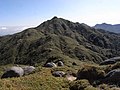 | registered in UNESCO World Heritage Site as "Yakushima". Miyanoura 日本の主な山岳標高:鹿児島県(国土地理院、2010年12月28日閲覧) Media related to Mount Miyanoura at Wikimedia Commons... 1 KB (76 words) - 13:47, 23 August 2023 |
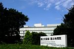 | The Geospatial Information Authority of Japan (国土地理院, Kokudo Chiri-in), or GSI, is the national institution responsible for surveying and mapping the national... 6 KB (598 words) - 21:22, 10 January 2024 |
 | コトバンク. 日本国語大辞典. Retrieved 28 October 2023. Titsingh, Isaac. (1834). Annales des empereurs du japon, p. 414. 中野犬小屋本論『武蔵野歴史地理. 第2冊』高橋源一郎編, 武蔵野歴史地理学会, 1928... 18 KB (1,977 words) - 14:04, 15 December 2023 |
13, 2020. "2022年度番組主な新キャスター" (PDF). Retrieved February 10, 2022. "2010年度日本地理学会賞(団体貢献部門)受賞者決定のお知らせ". The Association of Japanese Geographers. March 9,... 9 KB (959 words) - 01:13, 12 March 2024 |
 | 25000:1 札内川上流 荒井魏 『日本三百名山』 毎日新聞社編、1997年 "標高値を改定する山岳一覧 資料2" (PDF). 国土地理院. Retrieved 2014-03-26. GNSS測量等の点検・補正調査による2014年4月1日の国土地理院『日本の山岳標高一覧-1003山-』における改定値。なお、旧版での標高は1... 5 KB (534 words) - 23:41, 20 October 2023 |
 | 2021. Ha, Yeon; Geum, Yu; Gim, Bin (1425). Gyeongsang-do Jiriji 경상도지리지(慶尙道地理志) [Geography of Gyeongsang Province] (in Korean). Joseon Korea. Yi, Haeng... 24 KB (2,203 words) - 00:18, 10 April 2024 |
 | means "river spawning salmon and trout." There is a mountain of the same name "Ichankoppesan" nearby. 国土地理院 基準点成果等閲覧サービス 『山渓カラー名鑑 日本の山1000』山と渓谷社、1992年... 2 KB (113 words) - 02:47, 9 August 2023 |
 | Region Geospatial Information Authority of Japan") (in Japanese) 国土地理院刊行 地図一覧図 日本地図センタ] ("Published by Geospatial Information Authority of Japan Map List... 24 KB (2,765 words) - 14:50, 6 March 2024 |