 | Volcanic Complex (阿寒岳) Daisetsuzan Volcanic Group (大雪山) Mount Poroshiri (幌尻岳) Mount Rausu (羅臼岳) Mount Rishiri (利尻岳) Mount Shari (斜里岳) Mount Tokachi (十勝岳)... 10 KB (1,099 words) - 11:02, 17 January 2024 |
 | Japan Parent range Hidaka Mountains Topo map Geographical Survey Institute (国土地理院, Kokudochiriin) 25000:1 幌尻岳, 50000:1 幌尻岳 Geology Mountain type Fold... 1 KB (54 words) - 19:43, 24 June 2017 |
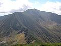 | Mount Poroshiri (幌尻岳, Poroshiri-dake) or sometimes Mount Horoshiri is located in the Hidaka Mountains, Hokkaidō, Japan. Its name was derived from a phonetic... 5 KB (435 words) - 06:17, 26 December 2023 |
Japan Parent range Hidaka Mountains Topo map Geographical Survey Institute (国土地理院, Kokudochiriin) 50000:1 幌尻岳, 25000:1 ピパイロ岳 Geology Mountain type Fold... 2 KB (71 words) - 19:15, 24 June 2017 |
 | Name Height Mount Poroshiri (幌尻岳, Poroshiri-dake) 2,052.8 metres (6,734.9 ft) Mount Kamuiekuuchikaushi (カムイエクウチカウシ山, Kamuiekuuchikaushi-yama) 1,979.4... 16 KB (821 words) - 07:34, 18 December 2023 |
Location Hokkaidō, Japan Parent range Hidaka Mountains Topo map Geographical Survey Institute (国土地理院, Kokudochiriin) 25000:1 幌尻岳 Geology Mountain type Fold... 1 KB (22 words) - 19:10, 6 February 2018 |
Japan Parent range Hidaka Mountains Topo map Geographical Survey Institute (国土地理院, Kokudochiriin) 50000:1 幌尻岳, 25000:1 ピパイロ岳 Geology Mountain type Fold... 949 bytes (22 words) - 07:29, 9 November 2016 |
Nukabira River (額平川, Nukabira-gawa). Geographical Survey Institute map 25000:1 幌尻岳 last access 26 March 2008 Shyun Umezawa, Yasuhiko Sugawara, and Jun Nakagawa... 2 KB (81 words) - 10:31, 19 November 2019 |
 | (50 mi), the river empties into the Pacific Ocean. 地図閲覧サービス 2万5千分1地形図名: 幌尻岳(夕張岳) (in Japanese). Geographical Survey Institute. Retrieved 2009-05-20.... 4 KB (149 words) - 18:57, 25 February 2022 |