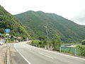
 | on the island of Shikoku, with a total length of 115.6 km (71.83 mi). "一般国道の路線別、都道府県別道路現況" [Road statistics by General National Highway route and prefecture]... 1 KB (75 words) - 21:36, 20 March 2024 |
National Route 1 (国道1号, Kokudō Ichi-gō) is a major highway on the island of Honshū in Japan. It connects Chūō, Tokyo in the Kantō region with the city... 66 KB (842 words) - 08:45, 8 May 2024 |
National Route 4 (国道4号, Kokudō Yongō) is a major national highway in eastern Honshū, Japan. Measuring 738.5 kilometers long (458.9 mi), it is the longest... 70 KB (1,026 words) - 08:40, 8 May 2024 |
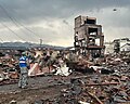 | doshakuzure kokudō 8-gō fukkyū mitōshi tatazu Nīgata Jōetsu" 能登半島地震で土砂崩れ 国道8号 復旧見通し立たず 新潟 上越 [Landslide caused by Noto Peninsula earthquake, National Route... 238 KB (22,887 words) - 23:04, 4 May 2024 |
National Route 350 (国道350号, Kokudō Sanbyaku gojūgō) is a national highway of Japan that traverses the prefecture of Niigata in a southwest–northeast routing... 11 KB (559 words) - 12:12, 7 August 2023 |
Kumakōgen, Ehime in Japan, with a total length of 66.8 km (41.51 mi). "一般国道の路線別、都道府県別道路現況" [Road statistics by General National Highway route and prefecture]... 1 KB (72 words) - 21:35, 20 March 2024 |
 | Tsushima and Iki, as well on Kyushu. Route 382 in Yobuko, Saga Prefecture. "一般国道の路線別、都道府県別道路現況" [Road statistics by General National Highway route and prefecture]... 1 KB (93 words) - 21:36, 20 March 2024 |