 | National Route 238 (国道238号, Kokudō Nihyaku sanjūhachi-gō) is the northernmost of the national highways of Japan. It connects the cities of Abashiri and... 9 KB (207 words) - 22:57, 25 June 2023 |
 | National Route 7 (国道7号, Kokudō Nanagō) is a major north-south national highway on the Sea of Japan side of the island of Honshū, Japan. It traverses four... 35 KB (473 words) - 01:55, 18 March 2024 |
 | National Route 236 (国道236号, Kokudō nihyakusanjūroku-gō) is a national highway connecting Obihiro, Hokkaido and Urakawa, Hokkaido in Japan. Length: 139... 3 KB (237 words) - 22:29, 17 March 2024 |
National Route 58 (国道58号, Kokudō Gojūhachi-gō) is a Japanese national highway connecting the capital cities Kagoshima and Naha of Kagoshima Prefecture... 30 KB (1,850 words) - 21:42, 17 March 2024 |
 | National Route 340 (国道340号, Kokudō Sanbyakuyonjūgō) is a national highway of Japan connecting the cities of Rikuzentakata, in southeastern Iwate Prefecture... 10 KB (168 words) - 10:13, 7 August 2023 |
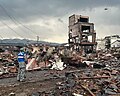 | doshakuzure kokudō 8-gō fukkyū mitōshi tatazu Nīgata Jōetsu" 能登半島地震で土砂崩れ 国道8号 復旧見通し立たず 新潟 上越 [Landslide caused by Noto Peninsula earthquake, National Route... 238 KB (22,887 words) - 23:04, 4 May 2024 |
National Route 39 (国道39号, Kokudō Sanjūkyū-gō) is a Japanese national highway connecting the two cities of Asahikawa and Abashiri in northeastern Hokkaido... 16 KB (503 words) - 16:50, 15 March 2024 |
2020. 瓦石峡乡 1950年建区公所,1953年后改为瓦石峡乡,1960年成立瓦石峡公社,1984年重设瓦石峡乡。位于县城西北80千米处。315国道从乡境中部穿过。面积2.4万平方千米,人口0.4万,其中维吾尔族占43.9%,汉族占43.2%,辖乌都勒吾斯塘、吾塔木、新建、瓦石峡牧业4个行政村。... 11 KB (752 words) - 00:01, 30 September 2023 |
 | Urakawa, Hokkaidō in Japan, with a total length of 260 km (161.56 mi). "一般国道の路線別、都道府県別道路現況" [Road statistics by General National Highway route and prefecture]... 1 KB (71 words) - 22:29, 17 March 2024 |
Rumoi, Hokkaidō in Japan, with a total length of 346.6 km (215.37 mi). "一般国道の路線別、都道府県別道路現況" [Road statistics by General National Highway route and prefecture]... 1 KB (72 words) - 22:30, 17 March 2024 |