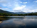
 | The Ono comes down, via the Onogawa Fudo Falls (小野川不動滝). from Mount Azuma (吾妻山) in the north. Its water was selected in 1985 as one of the 100 Best Waters... 2 KB (255 words) - 00:44, 18 December 2023 |
 | / 37.722222°N 140.263611°E / 37.722222; 140.263611 Naming Native name 吾妻山 (Japanese) Geography Mount Azuma Location of Mount Azuma in Japan. Location... 4 KB (295 words) - 21:48, 14 January 2024 |
 | Adatara (安達太良山) Mount Aizu-Komagatake (会津駒ヶ岳) Mount Asahi (朝日岳) Mount Azuma (吾妻山) Mount Bandai (磐梯山) Mount Chōkai (鳥海山) Mount Gassan (月山) Mount Hachimantai... 10 KB (1,099 words) - 11:02, 17 January 2024 |
 | mountain's name, like: 吾妻山 and 吾嬬山 which is read as "Agatsuma-yama" (Mount Agatsuma). In the village Tsumagoi, the mountain is spelled 吾妻山. The mountain should... 4 KB (349 words) - 15:24, 27 November 2023 |
 | Japan. It is surrounded on the other sides by Mount Adatara and Mount Azuma (吾妻山), and is part of Bandai-Asahi National Park. This highland plateau was made... 2 KB (191 words) - 00:42, 18 December 2023 |
9210°E / 38.2607; 139.9210 (Mount Iide Environs) [12] Mount Azuma Environs 吾妻山周辺森林生態系保護地域 Fukushima 81.98 37°44′19″N 140°08′25″E / 37.7386°N 140.1403°E... 69 KB (1,121 words) - 15:10, 28 November 2023 |