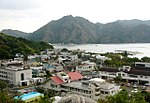
 | North Iwo Jima (redirect from 北硫黄島) North Iwo Jima (Japanese: 北硫黄島, Kita Iwōjima, "North Sulfur Island"), now officially North or Kita Iōtō (written with the same characters) and previously... 11 KB (966 words) - 00:16, 27 April 2024 |
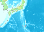 | (670 nmi; 771 mi) southeast of Miyazaki. The Volcano Islands are: Kita Iwo Jima (北硫黄島, Kita-Iō-jima / Kita-Iō-tō, literally North Sulphur Island), 5.57 square... 10 KB (638 words) - 11:01, 18 December 2023 |
 | (母島列島), 27.54 km2 Volcano Islands (火山列島, Kazan-rettō) 29.71 km2 Kita Iwojima (北硫黄島, Kita-Iōtō, lit. "North Sulphur Island") 5.57 km2 Iwojima (硫黄島, Iōtō, lit... 9 KB (646 words) - 19:40, 8 April 2024 |
 | 80 km (43 nautical miles, 50 mi) north of the island is North Iwo Jima (北硫黄島, Kita-Iō-tō, literally: "North Sulfur Island") and 59 km (37 mi; 32 nmi)... 52 KB (5,657 words) - 11:53, 23 April 2024 |
 | 874444°E / 27.246944; 140.874444 (Nishinoshima) 0.29 2008 3 North Iwo Jima 北硫黄島鳥獣保護区 Tokyo 25°26′17″N 141°16′59″E / 25.438082°N 141.282978°E / 25.438082;... 32 KB (712 words) - 19:25, 4 December 2021 |
 | Japanese). 69 (2): 30–35. doi:10.11475/sabo.69.2_30. ISSN 0286-8385. 区域図 聟島、西之島、北硫黄島 [Area Map: Mukojima, Nishinoshima, North Iwojima] (PDF) (in Japanese). Ministry... 6 KB (466 words) - 12:05, 27 April 2024 |