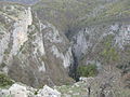
 | 00944; 46.82778 The Sulak Canyon (Avar: Сулахъ кӏкIал, Russian: Сулакский каньон) is a steep-sided deepest canyon in Europe carved by the Sulak River in... 4 KB (331 words) - 00:06, 28 March 2024 |
 | (only after a consonant [and] before the vowel "о"), such as in the words 'каньон' (canyon), 'шофьор' (driver), etc. It is called "ер малък" ('small er')... 27 KB (1,750 words) - 04:30, 7 April 2024 |
 | Великий каньйон Криму, romanized: Velykyi kanion Krymu; Russian: Большой каньон Крыма, romanized: Bolshoy kanon Kryma) is a canyon located in southern Crimea... 6 KB (614 words) - 04:23, 15 February 2023 |
 | (only after a consonant [and] before the vowel "о"), such as in the words 'каньон' (canyon), 'шофьор' (driver), etc. It represents the sound [j], unless after... 103 KB (4,846 words) - 01:30, 24 April 2024 |
 | The Long canyon (quarry) Russian: Длинный каньон (карьер) The Long canyon (quarry) Rostov oblast Russia Show map of Rostov Oblast The Long canyon (quarry)... 2 KB (177 words) - 00:57, 24 March 2023 |
the original on 2013-05-13. "K-42 Topographic Chart (in Russian)". Retrieved 25 October 2022. Google Earth. Географическая точка Каньон Шабакты v t e... 3 KB (142 words) - 11:23, 28 October 2022 |
growth. Lake Ostroye has one inflowing tributary, the Kan'on river (Russian: Каньон, lit. 'Canyone'), which brings water from the University Glacier. Besides... 9 KB (892 words) - 11:22, 18 March 2023 |
 | Earth Общая характеристика и классификация природных кормовых угодий Байкадамского сельского округа Жамбылской области Географическая точка Каньон Шабакты... 4 KB (276 words) - 17:12, 28 March 2024 |
The Dangi Canyon (Kyrgyz: Данги каньон) is a narrow passage of the river Aravansay in the Nookat District, Osh Region of southwestern Kyrgyzstan. It is... 2 KB (121 words) - 16:44, 20 September 2023 |
 | «Kazakh encyclopedia» ZhSS, 2011. ISBN 9965-893-64-0 (T.Z.), ISBN 9965-893-19-5 Google Earth Каратау - Paleokazakhstan Географическая точка Каньон Шабакты... 3 KB (193 words) - 17:25, 28 March 2024 |