
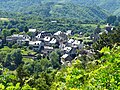
some 50 km east of Brive-la-Gaillarde and 30 km south by south-east of Égletons. The D13 road from Bassignac-le-Haut to Saint-Merd-de-Lapleau passes through...
9 KB (731 words) - 08:59, 18 January 2024

Montmorency Falls (redirect from Chute de Montmorency)
the falls is protected within the Montmorency Falls Park (French: Parc de la Chute-Montmorency). The falls are at the mouth of the Montmorency River...
9 KB (809 words) - 22:47, 18 October 2023

Gatineau Park (redirect from Parc de la Gatineau)
Gatineau Park (French: Parc de la Gatineau) is a federal park located in the Outaouais region of Quebec, Canada. Administered by the National Capital...
28 KB (3,232 words) - 01:17, 22 May 2024

It was formerly called Xaintrie. It is located some 30 km south-east of Brive-la-Gaillarde, 130 km south-west of Clermont-Ferrand, and about 180 km east...
10 KB (915 words) - 08:55, 18 January 2024

Puy de Mathonière, 1,295 meters Montagne de Riocros Haute, 1,294 meters La Motte, 1,277 meters La Chaux d'Espinchal, 1,230 meters Montagne de la Taillade...
30 KB (3,733 words) - 07:39, 20 May 2024

under the latters control. Astaillac is located some 45 km south-east of Brive-la-Gaillarde and 15 km north by north-west of Saint-Céré. The eastern border...
8 KB (607 words) - 08:58, 18 January 2024
capacity of 4 to 6 people; Five unserviced campsites on the shores of "Lac de la Montagne"; The Mount Sir-Wilfrid is covered by three storeys of tree types:...
4 KB (311 words) - 21:19, 16 December 2021

La Mauricie National Park (French: Parc national de la Mauricie) is a national park located near Shawinigan in the Laurentian mountains, in the Mauricie...
22 KB (2,137 words) - 10:46, 18 May 2024
join the Vézère west of Brive-la-Gaillarde. A number of streams rise in the commune to join the Corrèze including the Ruisseau de la Geinde, 2.7 km long,...
26 KB (2,457 words) - 19:30, 15 February 2024
Teillol The Ruisseau de la Font Blanc rises in the south of the commune which flows north gathering several tributaries and joining the Ruisseau de Rochette...
8 KB (654 words) - 08:54, 18 January 2024