
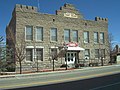
State Route 512 (SR 512) was a state highway in Carson City, Nevada. It connected Kings Canyon west of Carson City to the state capitol using various...
9 KB (936 words) - 04:42, 25 August 2020

Overland Route and later for the Lincoln Highway. Before the formation of the U.S. Highway System, most of US 50 in Nevada was designated State Route 2. The...
59 KB (4,937 words) - 08:28, 25 April 2024

following is a list of all State Routes that have existed in the U.S. state of Nevada since July 1, 1976. All active state-numbered highways in this list...
58 KB (637 words) - 03:09, 23 May 2024

following is a list of state routes in Nevada longer than one mile (1.6 km) in length that have been removed from the Nevada state highway system since...
65 KB (5,064 words) - 07:36, 23 June 2023

State Route 513 (SR 513) was a short state highway in Carson City, Nevada. The route was originally part of State Route 65, a longer highway that served...
8 KB (751 words) - 13:32, 16 April 2020
portion of the U.S. state of Nevada. As of the 2020 census, the population was 729, making it the least populous county in Nevada, and the 20th least...
20 KB (1,752 words) - 13:46, 26 April 2024

State Route 511 (SR 511) was a short state highway that followed West Washington Street in Carson City, Nevada. It was turned over to local control in...
3 KB (266 words) - 18:29, 4 May 2020

State Routes in Ohio are owned by the state, and maintained by the state except in cities. They are signed with a white silhouette of Ohio against a black...
191 KB (51 words) - 02:15, 2 June 2024

census-designated place (CDP) in Eureka County, Nevada, United States, directly off Nevada State Route 306. It is the site of Crescent Valley Elementary...
9 KB (686 words) - 06:19, 5 April 2024

a ghost town in Mineral County in the west central part of the US state of Nevada, approximately 22 mi (35 km) southwest of the town of Hawthorne, three...
13 KB (1,389 words) - 21:11, 24 March 2024