
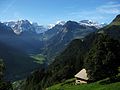
The Oberalpstock or Piz Tgietschen is a mountain in the Glarus Alps between the cantons of Uri and Graubünden. Its massif separates the valleys of Maderanertal...
2 KB (117 words) - 03:08, 5 May 2022
the Oberalpstock (3,328 m). Here occurs a partial break in the continuity of the chain. The crest of the snowy range connecting the Oberalpstock with...
10 KB (735 words) - 14:14, 27 May 2024

Piz Ault is a mountain of the Glarus Alps, located south of the Oberalpstock in Switzerland. Three ridges lead to the peak with a fourth one not very distinct...
2 KB (161 words) - 16:16, 15 May 2022

national speedboat champion and world-record holder Piaggio P.166 Mt. Oberalpstock / Swiss Alps hit mountain after loss of altitude due to heavy accumulation...
159 KB (2,557 words) - 16:51, 22 May 2024

Valley IT 1832 238 Oberalpstock 3328 703 46°44′34″N 08°46′10″E / 46.74278°N 8.76944°E / 46.74278; 8.76944 (238. Oberalpstock (3328 m)) Glarus Alps...
109 KB (1,721 words) - 11:57, 30 May 2024

the Oberalpstock (highest) and Piz Cavardiras (right) Highest point Elevation 2,964 m (9,724 ft) Prominence 243 m (797 ft) Parent peak Oberalpstock Coordinates...
1 KB (60 words) - 03:08, 5 May 2022
between the Swiss cantons of Uri and Graubünden. It lies west of the Oberalpstock, between the Etzlital and the Val Strem. Retrieved from the Swisstopo...
1 KB (61 words) - 16:16, 15 May 2022

Rochers de Naye Les Diablerets Wildhorn Dammastock Titlis Pilatus Tödi Oberalpstock Ringelspitz Piz Sardona Säntis Glärnisch Rigi Rheinwaldhorn Piz Medel...
76 KB (1,275 words) - 09:36, 22 May 2024

Güferhorn (11,132 ft.), the second summit of that region; in 1792, the Oberalpstock (10,926 ft), the highest point anywhere near Disentis; in 1793, the Piz...
4 KB (454 words) - 13:38, 16 March 2023

trail. "Topographic map of Piz Badus". opentopomap.org. Retrieved 2023-06-18. Swisstopo maps Oberalpstock on Summitpost Piz Badus on Hikr v t e v t e...
2 KB (87 words) - 03:14, 19 June 2023