
The Joglland is a heavily forested low mountain region in northeastern Styria in the districts of Hartberg-Fürstenfeld and Weiz. Today it forms the tourist...
2 KB (266 words) - 13:33, 11 February 2021
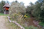
Source • location east of the Kreuzwirt, municipality of Wenigzell, Joglland • coordinates 47°22′47″N 15°48′19″E / 47.37972°N 15.80528°E / 47.37972;...
4 KB (176 words) - 12:20, 25 November 2021
especially the eastern Graz Uplands, the prominent Kulm massif and the Joglland with its peak, the Masenberg. To the east it is bounded by the Lafnitz...
3 KB (357 words) - 11:41, 21 May 2021

606 m above sea level (AA)) Bucklige Welt (Eselberg 974 m above sea level (AA)) Joglland (Hochwechsel 1,743 m above sea level (AA)) Kőszeg or Güns Mountains (Geschriebenstein...
3 KB (324 words) - 17:28, 29 May 2024
669 m above sea level (AA)). The Wechsel is the boundary between the Styrian Joglland and the Bucklige Welt, which stretches from the Vienna Basin to the extreme...
4 KB (346 words) - 14:07, 10 February 2021

Highlands) - SOIUSA code:II/A-20.III; Eastern Styrian Prealps (Wechsel-Joglland; Bucklige Welt; Bernstein-Güns; Rosalien-Ödenburg) - SOIUSA code:II/A-20...
3 KB (189 words) - 18:30, 26 September 2021

political district of Hartberg-Fürstenfeld. Rohrbach an der Lafnitz is in the Joglland, approximately 13 kilometres (8.1 mi) north of Hartberg city. It is located...
4 KB (272 words) - 10:18, 24 August 2023

St. Jakob im Walde, Birkfeld, Wenigzell and Vorau, the tourism agency "Joglland-Waldheimat". The base is in the town St. Jakob im Walde. In the election...
9 KB (480 words) - 16:42, 16 February 2024