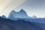
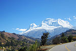
Champara or Champará is a mountain in the north of the Cordillera Blanca in the Andes of Peru and has an elevation of 5,735 metres (18,816 ft). It is located...
2 KB (107 words) - 05:22, 15 April 2022
Huaylas Province, Yuracmarca District. Collpa Janca lies northeast of Champará. Peru 1:100 000, Corongo (18-h). IGN (Instituto Geográfico Nacional - Perú)...
2 KB (149 words) - 05:25, 15 April 2022
986 ft) Pisco, 5,752 metres (18,871 ft) Paccharaju, 5,744 metres (18,845 ft) Champará, 5,735 metres (18,816 ft) Uruashraju, 5,722 metres (18,773 ft) Cayesh,...
18 KB (1,780 words) - 12:32, 29 April 2024
Saket Bairoliya 3:09 7. "Kasi Kasi" Chaitanya Prasad Navraj Hans 4:01 8. "Champara" Chaitanya Prasad Ram Gopal Varma 5:09 9. "Ayigiri Nandini" Sri Adi Sankaracharya...
9 KB (643 words) - 07:19, 25 April 2024
Cerro Barroso Peru 5,735 Champara Cordillera Blanca 8°41′14″S 77°46′52″W / 8.68722°S 77.78111°W / -8.68722; -77.78111 (Champara) Peru 5,730 Tunshu Cordillera...
61 KB (174 words) - 21:34, 18 April 2024
633 4736 9 Huaytapallana Peru 5,557 1,572 3985 10 Bravo Peru 3,970 1,571 2399 11 Pico Sira Peru 2,450 1,564 886 12 Champara Peru 5,735 1,509 4226...
19 KB (52 words) - 22:17, 6 December 2023
are distributed throughout 180 km, from the Tuku in the south up to the Champara in the north. Regarding its climate, there are two very well defined seasons:...
40 KB (3,840 words) - 10:40, 18 April 2024
located in the Ancash Region, Huaylas Province, Yuracmarca District, west of Champara. It lies at a lake named Quyllurqucha. escale.minedu.gob.pe - UGEL map...
2 KB (95 words) - 22:25, 15 April 2022

Pucaraju and Huandoy. Other mountains are listed below: Alpamayo Chaka Champara Hatun Hirka Hatun Kunka Kita Raqsa Kunka Kushuru Mashma Chaka Millpuq Millwaqucha...
5 KB (253 words) - 21:53, 18 April 2022
Huaylas Province, Ancash. It lies between Santa Cruz in the southeast and Champara in the northwest. Pilanco is located east of it. Los Cedros Creek flows...
2 KB (151 words) - 19:57, 16 February 2022