
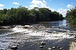
The Cedar Pocket Dam is a partially concrete gravity and rock and earth-fill embankment dam with an un-gated spillway located across the Deep Creek in...
5 KB (273 words) - 05:33, 23 September 2023
Cedar Pocket may refer to: Cedar Pocket Dam, a dam in the Wide Bay-Burnett area of Queensland, Australia Cedar Pocket, Queensland, a locality in the Gympie...
217 bytes (62 words) - 07:27, 2 January 2018

west of Montville, Six Mile Creek Dam on Six Mile Creek east of Cooroy, Cedar Pocket Dam on Deep Creek at Cedar Pocket, and two weirs (Talegalla and Teddington)...
24 KB (2,095 words) - 22:27, 21 March 2024

(primary coordinates) GPX (secondary coordinates) Dams and reservoirs in Australia is a link page for any dam or reservoir in Australia. There are three key...
76 KB (509 words) - 20:29, 25 September 2023

Bellmere – Bellthorpe – Booroobin – Bracalba – Camp Mountain – Campbells Pocket – Cedar Creek – Cedarton – Clear Mountain – Closeburn – Commissioners Flat –...
35 KB (1,261 words) - 02:04, 12 May 2024

South Wales 6–10 Cedar Street: Yungaburra Court House 7–9 Cedar Street: 7-9 Cedar Street, Yungaburra 12 Cedar Street: Residence 15–17 Cedar Street: Yungaburra...
21 KB (2,139 words) - 06:50, 5 June 2024

Cedar Breaks National Monument is a U.S. National Monument located in the U.S. state of Utah near Cedar City. Cedar Breaks is a natural amphitheater,...
13 KB (1,100 words) - 16:30, 3 April 2024
Milwaukee River (section Dams)
past Grafton to downtown Milwaukee, where it empties into Lake Michigan. Cedar Creek, the Menomonee River and the Kinnickinnic River are the three main...
11 KB (800 words) - 21:17, 7 April 2024

stretch of Cedar Pockets Wash, which arises on the southeast of Jarvis Peak, 6,530 feet (1,990 m), (the highpoint of the south Beaver Dam Mountains section)...
3 KB (367 words) - 14:30, 20 April 2024

several rock cuts bypass bends. The canyon opens up slightly at the Cedar Pocket interchange (exit 18), allowing for a rest area. This rest area was turned...
16 KB (1,520 words) - 04:51, 25 November 2022