Cape Géodésie (66°40′24″S 139°50′16″E / 66.67333°S 139.83778°E / -66.67333; 139.83778) is a low, ice-covered point marked by prominent rock outcrops...
875 bytes (135 words) - 11:50, 4 February 2021
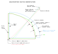
The Spatial Geodesy Research Group(French: Groupe de Recherche de Géodésie Spatiale, GRGS) is a French group established to advance space geodesy. It is...
5 KB (620 words) - 12:38, 31 May 2023

Retrieved 24 June 2014. Brial P., Shaalan C.(2009), Introduction à la Géodésie et au geopositionnement par satellites, p.8 Greenburg, John L. (1995)....
14 KB (1,926 words) - 16:06, 31 January 2024

Supplément au Traité de géodésie (1827) Nouvelle Description géométrique de la France (2 volumes, 1832–1840) Traité de géodésie (in French). Vol. 1. Paris:...
4 KB (334 words) - 02:13, 19 March 2022

interactive & collaborative map tool for smartphone available on google store: "géodésie de poche". Each terminal is fully detailed with lat/long/altitude RGF93...
15 KB (1,711 words) - 15:57, 20 May 2024
Encyclopædia Britannica. Vol. 8 (11th ed.). pp. 801–813. see page 811 Géodésie in Encyclopedia Universalis. Encyclopedia Universalis. 1996. pp. Vol 10...
12 KB (1,418 words) - 04:48, 13 March 2024

30 December 2023. Perrier, Général (1935). "Historique Sommaire De La Geodesie". Thalès. 2: 117–129, p. 128. ISSN 0398-7817. JSTOR 43861533. Badinter...
105 KB (11,276 words) - 12:47, 28 May 2024
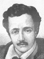
results of his explorations were published in Paris between 1860 and 1873 in Géodésie d'Éthiopie, full of the most valuable information and illustrated by ten...
24 KB (2,435 words) - 19:49, 29 May 2024
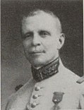
capacities in 1946. Perrier wrote the preface to Tardi's 1934 Traité de Géodésie, and the two were also editors of the Bibliographie Géodesique Internationale...
12 KB (1,012 words) - 21:55, 9 May 2024

pendulum observations at sea (PDF). Delft: Nederlandse Commissie voor Geodesie 2. p. 95. ISBN 978-90-6132-002-9. Archived from the original (PDF) on 2014-04-21...
13 KB (1,392 words) - 03:27, 19 March 2024