
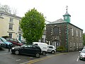
Camelford Town Hall is a municipal building in the Market Place, Camelford, Cornwall, England. The town hall, which is currently used as a public library...
8 KB (772 words) - 10:09, 10 August 2023
Camelford (Cornish: Reskammel) is a town and civil parish in north Cornwall, England, United Kingdom, situated in the River Camel valley northwest of Bodmin...
19 KB (1,989 words) - 02:52, 2 June 2024

This is a list of city and town halls in England. The list is sortable by building age and height, and provides a link to the listing description where...
241 KB (230 words) - 14:38, 10 June 2024

roads in Zone 3 of the Great Britain numbering scheme. Notes northeast of Camelford west of Launceston References See File:OS_Heathrow_5th_Edition.jpg...
54 KB (56 words) - 13:29, 18 May 2024

can be found on Tintagel Web. From 1894 to 1974, the parish was in the Camelford Rural District. As described in Geoffrey's popular Historia, Gorlois,...
46 KB (5,806 words) - 11:54, 3 May 2024

north Cornwall, England, in the United Kingdom. The nearest towns are Wadebridge and Camelford, each ten miles (16 km) away. A nearby hamlet, Port Gaverne...
15 KB (1,555 words) - 19:18, 27 February 2024
notes. Nottingham: The Russell Press [printer] (reissue of the edition Camelford, 1982) Royal Institution of Cornwall (1927) Journal of the Royal Institution...
6 KB (724 words) - 03:35, 26 February 2023
lived at Camelford House, Park Lane, as he wished to add to his new house, but enlarging it to the south would have detracted from Camelford, so in 1810...
10 KB (1,295 words) - 22:06, 9 December 2023

50.516°N 4.835°W / 50.516; -4.835. Other towns in the area are Launceston, Bude, Padstow, and Camelford. North Cornwall is an area of outstanding natural...
8 KB (596 words) - 11:59, 6 April 2024

50°26′41″N 4°56′35″W / 50.4447°N 4.9431°W / 50.4447; -4.9431 Trewan Hall (pronounced Trew-an) is a historic manor house in the parish of St Columb Major...
13 KB (1,700 words) - 00:27, 6 June 2024