
 French
 Deutsch
File:Europe 1878 map en.png
Size of this preview: 800 × 526 pixels. Other resolutions: 320 × 211 pixels | 640 × 421 pixels | 1,024 × 674 pixels | 1,280 × 842 pixels | 2,284 × 1,503 pixels.
Original file (2,284 × 1,503 pixels, file size: 1.01 MB, MIME type: image/png)
| This is a file from the Wikimedia Commons. Information from its description page there is shown below. Commons is a freely licensed media file repository. You can help. |
Summary
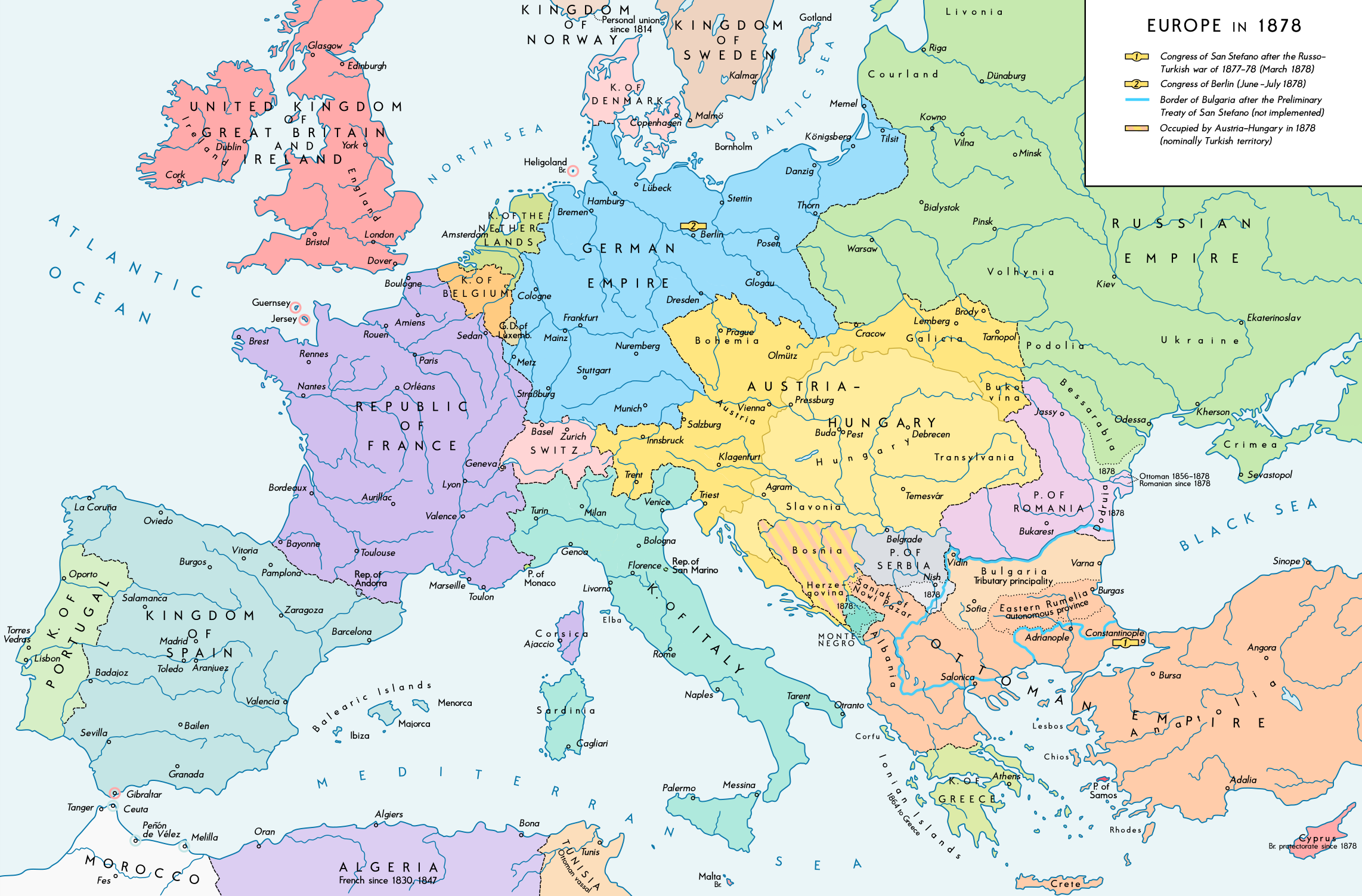
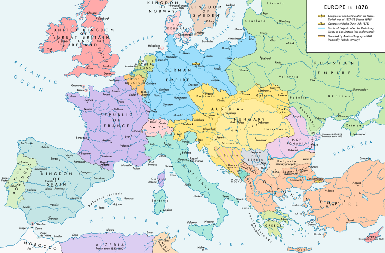
| Description | English: Europe 1878. Historical map of the political situation after the Congress of Berlin and the territorial and political rearrangement of the Balkan Peninsula. Please don't alter the map, when you think there something not written or depicted correctly. Leave a message at the talk page of the file. After a verificiation and a possible discussion, i will upload a new map version with all new changes. This prevents an unnecessary waste of disc space and ensures a good result, aesthetically and contentwise. - The author. Deutsch: Europa 1878. Historische Karte der politischen Situation nach dem Berliner Kongress und der politischen und territorialen Neuordnung des Balkans. Bitte die Karte bei Änderungs- und Korrekturwünschen nicht selbst verändern, sondern eine Anmerkung im Diskussionsbereich der Bilddatei hinterlassen. Nach einer Prüfung und ggfs. Diskussion werden evtl. Änderungen von mir zusammengefasst eingearbeitet. Das vermeidet unnötige Speicherplatz-Verschwendung und gewährleistet ein ästhetisch ansprechendes und inhaltlich korrektes Ergebnis. - Der Urheber. |
| Date | |
| Source | Own work. Source of Information: Historical atlases and maps – Ramsay Muir, George Philip (ed.): Philip's New School Atlas of Universal History, George Philip & Son, Ltd., London 1928 – Dr. Walter Leisering (ed.): Putzger Historischer Weltatlas, Cornelsen Verlag, Berlin 1992, ISBN 3-464-00176-8 – Bayerischer Schulbuch-Verlag (ed.): Großer Historischer Weltatlas, Dritter Teil, Neuzeit, Bayerischer Schulbuch-Verlag, München 1981, ISBN 3-7627-6021-7. – Prof. Dr. Vadim Oswalt u. Prof. Dr. Hans Ulrich Rudolf (ed.): Klett-Perthes Atlas zur Weltgeschichte, Ernst Klett Verlag, Stuttgart 2011, ISBN 978-3-12-828194-0 |
| Author | Alexander Altenhof |
| Other versions |
|

Recompressed without quality loss with OptiPNG (1.28 MB > 1.00 MB)
Licensing
I, the copyright holder of this work, hereby publish it under the following license:
This file is licensed under the Creative Commons Attribution-Share Alike 4.0 International license.
- You are free:
- to share – to copy, distribute and transmit the work
- to remix – to adapt the work
- Under the following conditions:
- attribution – You must give appropriate credit, provide a link to the license, and indicate if changes were made. You may do so in any reasonable manner, but not in any way that suggests the licensor endorses you or your use.
- share alike – If you remix, transform, or build upon the material, you must distribute your contributions under the same or compatible license as the original.
 | This historical map image could be re-created using vector graphics as an SVG file. This has several advantages; see Commons:Media for cleanup for more information. If an SVG form of this image is available, please upload it and afterwards replace this template with {{vector version available|new image name}}. It is recommended to name the SVG file “Europe 1878 map en.svg”—then the template Vector version available (or Vva) does not need the new image name parameter. |
File history
Click on a date/time to view the file as it appeared at that time.
| Date/Time | Thumbnail | Dimensions | User | Comment | |
|---|---|---|---|---|---|
| current | 23:54, 14 April 2017 | | 2,284 × 1,503 (1.01 MB) | KaterBegemot | {{Information |Description ={{en|1=Europe 1878}} |Source ={{own}} |Author =Alexander Altenhof |Date = |Permission = |other_versions = }} |
File usage
The following pages on the English Wikipedia use this file (pages on other projects are not listed):
Global file usage
The following other wikis use this file:
- Usage on no.wikipedia.org
- Usage on pnb.wikipedia.org
- Usage on ro.wikipedia.org
- Usage on sl.wikipedia.org
- Usage on ur.wikipedia.org