 | The United States Geological Survey (USGS), founded as the Geological Survey, is an agency of the United States government whose work spans the disciplines... 34 KB (3,688 words) - 20:33, 12 May 2024 |
A geological survey is the systematic investigation of the geology beneath a given piece of ground for the purpose of creating a geological map or model... 4 KB (445 words) - 15:41, 14 June 2022 |
 | States Geological Survey, United States Department of the Interior. "Lone Mountain". Geographic Names Information System. United States Geological Survey, United... 168 KB (13,958 words) - 21:44, 19 March 2024 |
 | The California Geological Survey, previously known as the California Division of Mines and Geology, is the California state geologic agency. Although... 8 KB (1,084 words) - 19:47, 21 October 2022 |
| The United States Geological Survey Library (USGS Library) is a program within the United States Geological Survey (USGS), a scientific bureau within the... 14 KB (1,634 words) - 03:15, 17 February 2024 |
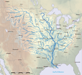 | segment of a river, as contrasted to its tributaries". The United States Geological Survey (USGS) defines a main-stem segment by listing coordinates for... 60 KB (3,151 words) - 13:11, 22 April 2024 |
 | Tapestry of Time and Terrain: The Union of Two Maps – Geology and Topography". United States Geological Survey. Archived from the original on May 15, 2006. Retrieved... 49 KB (5,634 words) - 16:03, 9 May 2024 |
January 2024). "M 7.5 - 2024 Noto Peninsula, Japan Earthquake". United States Geological Survey. Retrieved 1 January 2024. Ishikawa, Yuzo; Bai, Ling (2024)... 74 KB (3,726 words) - 18:51, 15 May 2024 |
January 2023). "M 5.5 - 9 km ESE of Jayapura, Indonesia". United States Geological Survey. Archived from the original on 1 January 2023. Retrieved 4... 323 KB (17,576 words) - 11:22, 11 May 2024 |
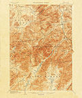 | Quadrangle (geography) (redirect from United States Geological Survey quadrangle) "quadrangle" is a topographic map produced by the United States Geological Survey (USGS) covering the United States. The maps are usually named after local physiographic... 4 KB (361 words) - 01:11, 20 August 2023 |