
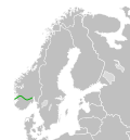
DescriptionEurope-Norway.svg English: (Green) Norway. (Light-green) ni. (Gray) Europe. (Light-gray) The surrounding region. See also categories: SVG locator...
(2,045 × 1,720 (7.31 MB)) - 14:04, 17 December 2023

image is a derivative work of the following images: File:European_Union_Norway_Locator.svg licensed with Cc-by-3.0 2009-08-14T16:48:18Z Tocino 2047x1720...
(593 × 606 (711 KB)) - 13:41, 20 November 2022

image is a derivative work of the following images: File:Blank_map_of_Europe.svg licensed with Cc-by-sa-2.5 2011-09-19T22:57:58Z Alphathon 680x520 (603759...
(450 × 456 (494 KB)) - 16:23, 30 January 2024
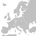
image is a derivative work of the following images: File:Blank_map_of_Europe.svg licensed with Cc-by-sa-2.5 2012-02-21T16:27:27Z Alphathon 680x520 (614699...
(450 × 456 (632 KB)) - 17:07, 26 November 2023
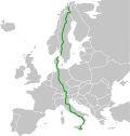
(Europe way route no. 45) starting Alta in Finnmark (northern Norway) going down Europe ending up in Gela city of Sicilia in southern Italy Norwegian Bokmål...
(401 × 420 (104 KB)) - 12:37, 26 April 2024
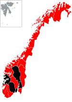
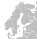
Map of H1N1 swineflu outbreak in Norway |Source = Norway counties.svg |Date = 05.21.2009 |Author = ~~~ |other_versions = Norway counties.svg }} English...
(744 × 1,052 (494 KB)) - 17:17, 11 November 2022
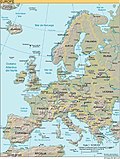
following images: File:Europe.svg licensed with PD-USGov-CIA-WF 2006-01-24T17:12:03Z Moyogo 506x670 (1031967 Bytes) [[User:Moyogo/SVG Maps|stripped useless...
(506 × 669 (39 KB)) - 15:19, 21 October 2020
of [[:Image:Blank map of Europe.svg|Blank map of Europe.svg]] as descriped by its author. {{en|A blank Map of Europe in SVG format. Every country has...
(645 × 690 (523 KB)) - 17:08, 26 November 2023
of [[:Image:Blank map of Europe.svg|Blank map of Europe.svg]] as descriped by its author. {{en|A blank Map of Europe in SVG format. Every country has...
(645 × 690 (526 KB)) - 17:08, 26 November 2023
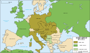
image is a derivative work of the following images: File:Map_Europe_alliances_1914-fr.svg licensed with Cc-by-sa-2.5,2.0,1.0, Cc-by-sa-3.0-migrated, GFDL...
(998 × 593 (90 KB)) - 09:31, 18 October 2020