
European Remote Sensing satellite (ERS) was the European Space Agency's first Earth-observing satellite programme using a polar orbit. It consisted of...
9 KB (1,003 words) - 17:39, 22 February 2024

remote sensing (when a signal is emitted by a satellite or aircraft to the object and its reflection is detected by the sensor) and "passive" remote sensing...
63 KB (7,740 words) - 04:48, 17 June 2024
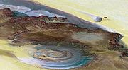
Remote sensing is used in the geological sciences as a data acquisition method complementary to field observation, because it allows mapping of geological...
62 KB (7,072 words) - 16:17, 17 June 2024
European Space Agency mission), European Remote Sensing Satellite 1 and 2 (ERS 1/ERS 2), the Japanese Earth Resources Satellite 1 (JERS 1), RADARSAT 1 and...
19 KB (1,881 words) - 07:56, 19 May 2024

observation satellite or Earth remote sensing satellite is a satellite used or designed for Earth observation (EO) from orbit, including spy satellites and similar...
15 KB (1,586 words) - 12:16, 1 April 2024
at that location. Remote sensing in oceanography mostly refers to measuring properties of the ocean surface with sensors on satellites or planes, which...
33 KB (4,474 words) - 01:32, 30 April 2024

as for the International Cospas-Sarsat Programme and the European Remote-Sensing Satellite. TSS became part of NSC in 1990, although it was partially...
18 KB (2,216 words) - 23:20, 8 May 2024
National Remote Sensing Centre (Hindi: राष्ट्रीय सुदूर संवेदन केन्द्र), or NRSC, located in Hyderabad, Telangana is one of the centres of the Indian Space...
2 KB (99 words) - 16:37, 29 May 2024

Air pollution measurement (section Remote monitoring)
ozone levels from the ESA European Remote Sensing Satellite (ERS-2) in 1995, and NASA's MAPS (Mapping Pollution with Satellites), which measured the distribution...
39 KB (3,787 words) - 20:26, 4 January 2024

Digital elevation model (section Satellite mapping)
stereoscopic correlation. Later, further data were provided by the European Remote-Sensing Satellite (ERS, 1991) using the same method, the Shuttle Radar Topography...
30 KB (3,236 words) - 14:45, 26 February 2024