
Remote sensing is the acquisition of information about an object or phenomenon without making physical contact with the object, in contrast to in situ...
62 KB (7,676 words) - 12:12, 25 April 2024
India's remote sensing program was developed with the idea of applying space technologies for the benefit of humankind and the development of the country...
12 KB (934 words) - 18:28, 3 May 2024
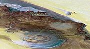
Remote sensing is used in the geological sciences as a data acquisition method complementary to field observation, because it allows mapping of geological...
58 KB (6,685 words) - 15:33, 12 April 2024
Remote sensing techniques in archaeology are an increasingly important component of the technical and methodological tool set available in archaeological...
16 KB (2,072 words) - 03:19, 24 November 2023
A remote sensing software is a software application that processes remote sensing data. Remote sensing applications are similar to graphics software, but...
3 KB (317 words) - 12:14, 17 June 2023
The Pakistan Remote Sensing Satellite (PRSS), is an earth observation optical satellite launched from China's Jiuquan Satellite Centre on 9 July 2018....
6 KB (404 words) - 15:05, 18 May 2024
Remote sensing may also refer to: Remote Sensing (journal), a scientific journal Remote sensing (archaeology) Remote sensing (geology) Remote sensing...
550 bytes (97 words) - 18:09, 13 November 2023
National Remote Sensing Centre (Hindi: राष्ट्रीय सुदूर संवेदन केन्द्र), or NRSC, located in Hyderabad, Telangana is one of the centres of the Indian Space...
2 KB (99 words) - 16:37, 29 May 2024

In electrical engineering, four-terminal sensing (4T sensing), 4-wire sensing, or 4-point probes method is an electrical impedance measuring technique...
5 KB (657 words) - 09:19, 22 January 2023
Flash drought (category Remote sensing)
explored their impacts on agriculture, ecosystems, and water resources. Remote sensing data, such as satellite-derived measurements of soil moisture, evapotranspiration...
4 KB (355 words) - 08:56, 30 April 2024